
Review of the federal capital territory master plan
This article is titled "Symptoms of Distress", and is structured to look at our Federal Capital as a living organism, to identify some of the areas that are not working as planned.
D riving into Federal Capital Territory (FCT) from the Keffi axis, visitors are confronted with a bewildering array of construction especially along access roads. A view from the air shows sprawl in every direction but why this growth is taking place? To a large degree it is a reflection of the inability of the FCT to provide space at affordable rates to the informal sector which is the largest sector of the economy and indeed the major fuel for the development of settlement. Along this axis which is outside the jurisdiction of the Federal Capital Development Agency (FCDA), it is easier for individuals to acquire land and seek approval after. This allows them locate what they wish where they wish with fewer problems.
While some effort has been made to control development within FCT, the same cannot be said of FCDA. There are several developments that have become major problems such as Mpape. Mpape is not alone; developments in Kubwa, Bwari, Gwagwalada and other such settlement are not better planned or regulated. These developments defeat one of the stated aims of relocating capital of the country Nigeria from Lagos, which was to have more orderly development. The same laissez-faire approach to planning and development control is in force leading to a response to crises rather than prevention of crises.
"The master plan is expected to capture the soul that is maintained irrespective of changes that may be made over time. Does Abuja have a soul?”
Many of the major institutional buildings are not located where planned. The most prominent is the Seat of Government, Aso Rock. In the original plan, the seat presidential authority was to be the Presidential Palace located on the Mall near the National Square.
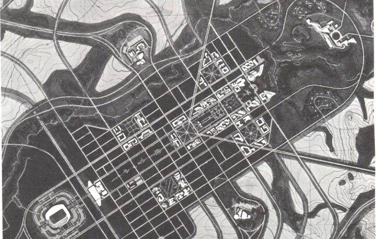
The success of failure of Abuja Master Plan depended on understanding and implementing the residential components. It is relatively easy to control where institutional structures go. It is more difficult to control residential areas because of the number of individual players and support services needed to support viable communities. The original plan was simple and intuitive. In planning terms it was modelled somewhat on the Radburn model of neighbourhood development. Below the city level, there were sectors; sectors were made up of many districts each with a district centre. Each sector was to be conceived as a mini city of between 100,000 and 250,000 inhabitants. By that conception, the sector was to have employment capable of supporting the population served.

The implication was that non residential facilities were to be placed to obtain quick and in many cases walkable distances for residents. Sector facilities were to be at the “confluence” of several districts. Each residential district was to house between 40,000 and 60,000. A transportation corridor made up a parallel rail transit system that focuses on the central core. In addition there are a series of parkways radiating from the core or cutting across the two arms of the plan. The parkways enclose the sectors as shown in figure below. In a sense each sector can conceivable function autonomously.
The form Abuja is in today is the result of the cumulative effects of decisions and actions by several administrations over the years. While planners may be blamed, the blame would be valid only if they did not point out the distortions when they were being proposed; for example, when the seat of presidential power was moved from the Mall to Aso Rock, or when the Women’s Centre was located in the area of the Mall or when only half of the streets in the Central Area were being built; what was the reaction or input of the planners in FCDA. If they did not say anything then they are also responsible for the distortions.
First, I do not think trying to force our way back to the original plan in a wholesale manner is neither possible nor sensible. With our limited resources, it seems wasteful to spend such energy on reclaiming the plan. However there are some practical issues that would necessitate reclaiming some of the lost areas. One such area would be the green areas which not only beautify, but also serve as water channels thereby preventing urban flooding in the event of extreme weather. Constructing concrete drains is an expensive solution to what could be accomplished purely through legislation and regulating of the use of low lying area. Of course some urban use must be found for these areas so that they do not become wild land to be used by miscreants and antisocial elements.
Secondly there is a need to cast a new vision for the city. This begs the question as to who the visioner should be. Planners cannot be the visioners because they do not have the political and administrative authority to ensure implementation. Ideally it needs to be the political class, not as a partisan group but as a collective, such that while personnel, parties, and even governments may change, the vision is sustained through the changes. It is only then that there can be hope of reaching a goal. Cities take generations to develop.
Author: Professor (Tpl.) Timothy T. Gyuse, PhD; FNITP, RTP
Professor of Urban Design and Planning
Benue State University, Makurdi

